Water on the Web
B. Introduction
What is WOW?
Students Monitoring Minnesota Lakes Through the Internet
Water on the Web (WOW) is a project that allows high school
and college students to monitor Minnesota lakes over the Internet. WOW
integrates state-of-the-art environmental monitoring with geographic information
systems, data visualization, and in-depth educational materials. Our primary
goal is to train students to solve real world problems.
Water on the Web is a three-year cooperative educational
project funded by the National Science Foundation that began in 1997. After
three years, a Water on the Web curriculum will be available which will
allow high school, community and technical college students to use state-of-the-art
technology to monitor lakes across Minnesota without leaving the comfort
of their classrooms.
Water on the Web links University of Minnesota institutions
with private industry, community and tribal groups, Minnesota's high schools,
community colleges, technical colleges, and natural resource and regulatory
agencies. Take a minute to view our staff pages, curriculum writers, national
advisory committee and our collaborators web pages.
Water on the Web is:
-
Educational
-
High-tech
-
Useful to water managers, lake shore owners, and anglers
-
A great way to find out about the health of our lakes!
Special lessons will help students understand the data from
several water sampling robots, called Remote Underwater Sampling Station
(RUSS) units. Two units have been placed in Ice Lake and Lake Independence
in Minnesota. Two more are scheduled for placement in Lake Mille Lacs and
the St. Louis River as it empties into Lake Superior. The RUSS units will
provide current water conditions from these diverse water bodies through
the Internet.
Each unit includes a solar-powered water quality instrument
capable of making several measurements at different depths throughout the
day. This allows students to investigate a lake’s water quality by designing
their own experiments and sampling programs. The students will program
the time and depth of measurements into the RUSS units through an on-board
cellular telephone linked to their classroom computers through the Internet
and special RUSS software. Data will also be made available to the public
through the Internet Web site.
What do the RUSS units measure?
-
Water temperature
-
pH (how acid or alkaline the water is)
-
Conductivity (how "hard" or "soft" the water is)
-
Turbidity (clarity)
-
Depth of water sample
-
Dissolved oxygen content
These measurements can provide and accurate picture of how
a lake or watershed functions and how healthy it is. Additional sensors
to measure algae and nutrients are in development.
Why is this project important?
The curriculum will be used to train students in water resources
and advanced technology, helping them better manage our natural resources
in the future. The RUSS units can help current water managers because they
provide continuous, year-round information on the conditions of lakes,
something that’s not readily available now. The information will also be
useful to anglers, lake associations and shoreland property owners.
Beginning in January 1999 a new study by HCP, the Minnehaha
Creek Watershed District (MCWD), the Science Museum of Minnesota, and the
WOW team will begin for the purpose of increasing public understanding
of monitoring data for better managing water resources. The project will
be funded by the US environmental Protection Agency (EPA) EMPACT program
and will utilize Lake Independence data and RUSS units at two sites in
Lake Minnetonka.
(taken from Water on the Web pages, http://wow.nrri.umn.edu/wow/overview.html)
Goals of embedding data into the curriculum
The narrated presentation of Water on the Web gives same hints, how data
and Data Analysis should be integrated into the project in school. Die
Präsentation existiert bei der neuen Version von Water on the Web
nicht mehr. Momentan kann sie aber noch in der alten eingesehen werden,
die man unter der Adresse: http://wow.nrri.umn.edu/original/
findet.
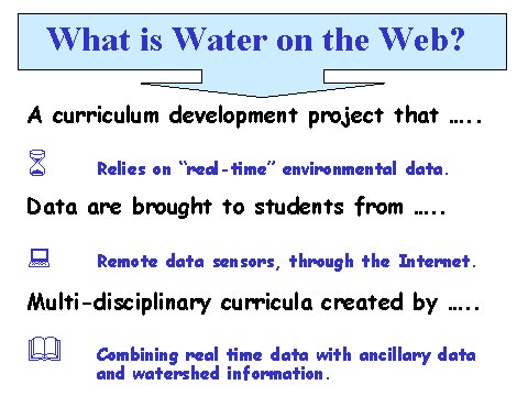
At first they stress, that the project is based on “real time” environmental
data. The students get the data through the Internet and the task of the
students is to combine the real time data with ancillary data and watershed
information.
(Graph taken from WOW-Presentation (http://wow.nrri.umn.edu/original/powerPt/htmlVsn/sld002.htm))
The curriculum consists of the following topics at the moment:
-
Aquatic Respiration
-
Chemistry of Oxygen Solubility
-
Conductivity
-
Data Interpretation
-
Diel Temperature Variation in Lakes
-
Effect of pH
-
Effect of Photosynthesis and Respiration on Aquatic Chemistry
-
Fish Stocking Decisions
-
Heat Budgets of Lakes
-
Modeling Water Quality
-
Properties of Water
-
Rain Storms, Landuse and Lake Turbidity
-
Thermal Stratification
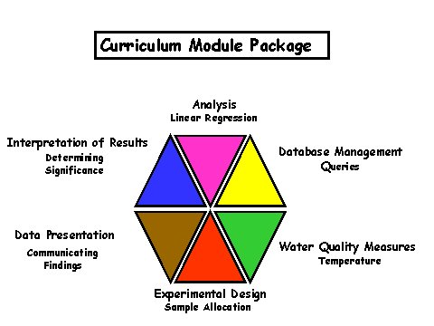
Each of these lessons contains components of six
different learning domains that the curriculum authors consider as critical
to improve scientific and technological literacy: knowledge base, experimental
design, data collection, data management and analysis, interpretation of
results, and reporting results. We see that all units contain aspects of
data analysis and not only Unit 4, which puts data interpretation in the
foreground. In the old version of the Water on the Web Curriculum, a relationship
between the modules was visualized by means of the following diagram:
(Graph taken from WOW-Presentation (http://wow.nrri.umn.edu/original/powerPt/htmlVsn/sld010.htm))
We see that all steps of a complete analysis of data can become part
of the lessons starting from data collection and finishing with the presentation
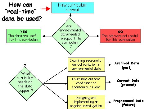
of results. A new curriculum concept is necessary to use "real-time" data.
Three ways are suggested to use "real-time" data. But all ways desire are
different kinds of data. To examine seasonal or annual variation you need
archived data. To investigate current conditions or spontaneous events
you need current data. For an ongoing investigation programmed data are
required.
(Graph taken from WOW-Presentation (http://wow.nrri.umn.edu/original/powerPt/htmlVsn/sld012.htm))
Structure of the Water on the Web pages
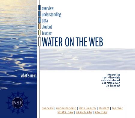
The web site of the project is easily structured so that one can orient
oneself without many problems. There are six domains that can be entered
from the Water
on the Web Homepage.
(http://wow.nrri.umn.edu/wow/index.html)
Users who visit the Water on the Web pages for the first time can find
basic information about the project under Overview.
Students and teachers who are regularly using Water on the Web can find
out under what's
new whether changes occurred since their last visit or whether interesting
events have occurred in the meantime (for instance, that all lakes have
become frozen). All other information for supporting the normal work with
the project can be found under the four options: understanding, data, student
and teacher.
Under understanding
important background information for the topic of the project can be found.
Beside the large Glossary,
which explains all used terms, you can find site links to informations
about the RUSS-Unit,
to important facts about the
Lakes, as for example: size, location, etc., to the Lake
Ecology primer that explains the connections among the physical, biological
and chemical components and to the geographic information system (GIS)
which gives you the possibility to view interactive maps. The information
about the RUSS-Unit contains also explanations of all measured variables.
These explanations include the question: "Why is it important?" and a chapter
about "reasons for natural variation". The "expected impact of pollution"
is also discussed. For some variables some specialties are explained,
like the relation between acid rain and pH.
Student
and
Teacher
contain different versions of the curriculum. Water on the Web has three
versions of the curriculum, one for teachers and two different ones for
students. For students we can find "studying" lessons and "investigating"
lessons. "Studying" lessons allow the students to apply and learn concepts
through direct, guided experiences. The "Investigating" lessons provide
more opportunities to discover the concepts and involve more problem-solving.
The student curriculum only contains the specific activities and numerous
work sheets, the teacher curriculum contains further information about
intended learning goals, needed time, and in particular so-called teachers'
notes, which contain important information about the correct solutions
of the various tasks and activities. The structure
of the curriculum will be presented in more detail later.
Under data
we can find everything that is related to the collected data about the
lakes. We can find raw data as well as aggregated and prepared data sets.
Moreover, several tools for visualizing data can be found as well. We will
now present and discuss the data sets and tools.